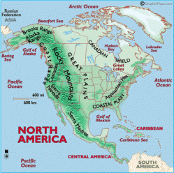
US and Canada Physical Geography
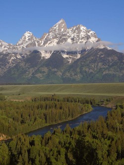
The Rocky Mountains
The Rocky Mountains is a stripe of mountains that run from Mexico to Alaska. This mountain range is the largest in the continent. Here it is rugged and there are very high mountains. This means these mountains are not old and much younger than the Appalachian Mountains. There are rivers that begin in this region and branches off into the rest of the continent. Rivers mean more water source for the U.S. and Canada.
Click for more info- Rocky Mountains
Click for more info- Rocky Mountains
Appalachian Mountains

The Appalachian Mountains are located on the Eastern side of the United States and Southeast part of Canada. In Canada they call it the Appalachian Highlands and the U.S. calls it the Appalachian Mountains. These mountains are the oldest in the continent. Here the mountains are more rounded like you see in picture. The Appalachian Mountains are the second largest mountain range in the continent. Up more in Canada there are farmlands in the valleys and lots of forests.
Click for more info- Appalachian
Click for more info- Appalachian
Great Lakes

The Great Lakes is found in the northern part of the United States and is shared with Canada. The lakes are the largest group of freshwater in the world. There are lots of boats that carry production goods and provide tranportation across the lakes. There are also alot of rivers that begin here off these lakes.
Interior Plains

The Interior Plains covers the center of Canada and all of the Mid-West region of the United States. Here there are lots of thick forest and huge rolling prairies and grasslands. In the U.S. there are broad river valleys and Canada has many lakes in this region. In this area there are fields of grain and grassy hills and pastures in the United States. For Canada there is fertilized soil and this is where natural gas and petroleum is from.
Border Pacific

Both the U.S. and Canada border the Pacific Ocean. The Pacific is on the Western side of the continent. In the U.S., west of the Pacific mountains, are coastal lowlands and fertile valleys. In the southern and central mountains, they are broken up by lowlands and plateaus. In Canada, this is where Canada's highest peak, Mount Logan, is located.
