Canada's Physical Geography
Hudson Bay
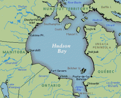
Hudson Bay is a large body of water in the Northeastern part of Canada. It is one of the largest ocean inlets in the world. There are alot of rivers that empty here at the bay. The Eastern shore is rugged and there are alot of islands. The Western shore is low and swampy.
Click for more info- Hudson Bay
Click for more info- Hudson Bay
Climate

There are not as many climate regions in Canada as there are in the U.S. One of them is the Subarctic which covers most of the continent. Another one is the Tundra and is located on the Northern part of Canada and all the islands above. The Southern part of Canada consists of: Humid Continental, Steppe, Marine West Coast, and Highland. This means Canada has a cooler climate and not a lot of temperature change if going North.
Canadian Shield and Arctic Island

The Canadain Shield and Arctic Islands are ice and snow that cover over half of Canada. There are 10 large islands that are part of the Arctic Islands. In this region you would not find any farms because of all the snow and ice. Though there are mosses and shrubs that grow in this area that can handle the weather. In the Southern part of this region there are evergreen forests. In this region there are iron ore, copper, nickels and dimes.
Click for more info- Canadian Shield
Click for more info- Canadian Shield
St. Lawerence and Great Lakes Lowlands

The St. Lawerence and Great Lakes Lowlands are mainly in the Southeasten part of Canada. In this region of Canada there are urban areas with industries. There are lowlands with rich soil so there are lots of farms here. Also in this region there are major waterways leading into central Canada.
